
Table of Contents
- Socotra's Geology in One Minute: The Key Facts
- How Socotra Was Formed: Socotra's Origins & Geological History
- The Four Building Blocks of Socotra's Landscape
- Reading the Rocks: Socotra's Stratigraphy in Order
- Karst and Caves: The Hidden Half of Socotra
- Wind, Water and the Sculpting of the Surface
- What the Coastline Tells Us about Sea Level
- Top Geological Landmarks to Visit
- Beyond the Main Island
- Practical Tips for Geology-Minded Travelers
- Common Misconceptions about Socotra's Geology
- FAQs about Socotra Geology
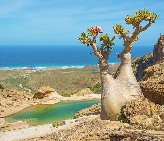
Have you ever wondered how the Socotra geology was formed? When you stand on the limestone plateau of Socotra and admire the silhouette of the dragon's blood tree, or discover a shiny peralkaline granite in the Hajhir Mountains, you unlock your Socotra tour with a geological epic spanning 800 million years.
So when you plan a trip to Socotra Island, take a moment to learn about the fascinating geology of Socotra.
Socotra's Geology in One Minute: The Key Facts
Basement age: ~700–800 million years (Neoproterozoic), formed ~15 km underground
Is it volcanic: No. It’s a continental fragment of Gondwana.
Rock trio: Granite/gneiss core → Cretaceous–Eocene limestone plateaus → Quaternary sands & dunes
Final separation from Africa/Arabia: Oligocene–Miocene rifting, ~20–18 Ma
Highest point: Jabal (Skand) Mashanig in the Hajhir Mountains, ~1,500–1,526 m
UNESCO Recognition: UNESCO World Heritage since 2008
How Socotra Was Formed: Socotra's Origins & Geological History
The Breakup of Gondwana and Continental Rifting
800 Ma
The core of Socotra consists of ancient crystalline basement rocks. The oldest rocks on Socotra Island belong to the Precambrian Basement. These basement rocks mainly consist of metamorphic rocks (such as schist and gneiss), intrusive rocks (granite and diorite), and volcanic rocks (andesite, rhyolite, and basalt). The Hajhir Mountains are the largest exposed area of basement rocks. If you want to learn about the geology of Socotra, the Hajhir Mountains must be visited during your Socotra tour.
780–600 Ma
This period corresponds to the formation of the Arabian-Nubian Shield (ANS), a key component of the East African Orogeny. The ANS formed through the closure of the Mozambique Ocean and the accretion of island arcs and terranes onto the eastern margin of Gondwana.
The basement rocks of Socotra are considered a southern extension of this shield, sharing similar Precambrian suites with the Arabian margin, particularly the Dhofar region of Oman. This orogenic episode welded the island's ancient crust firmly to the Gondwanan landmass.
150–100 Ma
During the Early Cretaceous, Gondwana breaks apart. Rifting between the future African, Arabian, Indian, and Antarctic plates initiated the opening of the western Indian Ocean.
Extensional tectonics along the southern margin of the Arabian plate created rift basins. In the area of Socotra, this led to the deposition of fluvial and shallow-marine clastic sediments, such as sandstones, on the subsiding continental shelf. These were the first of a thick succession of sedimentary rocks that would later blanket the basement.
100–34 Ma
Throughout the Late Cretaceous and Paleogene, Socotra's passive margin setting allowed for prolonged thermal subsidence. Thick sequences of marine limestones and marls were deposited in warm, shallow seas that repeatedly covered the region. These carbonates now form the dramatic escarpments and plateaus of the island. This period was marked by relative tectonic quiescence, with the primary geological process being the steady accumulation of sediment on the continental shelf.
34–18 Ma
The Oligocene to Early Miocene epoch witnessed a major tectonic reorganization: the formation of the Gulf of Aden rifting. Continental rifting, driven by the Afar mantle plume (also called the Afar plume), began to separate the Arabian plate from the African plate.
Socotra, located on this margin, was rifted from the Dhofar coast of Oman. Normal faulting and crustal thinning fragmented the older carbonate sequences and initiated the island's characteristic tilted-block topography. This event established Socotra as a continental fragment within the nascent ocean basin.
9–6 Ma to Today
From the Late Miocene through the Quaternary, post-rift thermal uplift and renewed compressional stresses shaped Socotra's final form. The island experienced slow but continuous uplift, exhuming the Precambrian basement in its central mountains and carving deep canyons.
At the same time, Quaternary sea-level fluctuations during glacial cycles periodically exposed shallow shelves, potentially allowing brief land bridges to the Horn of Africa. These processes, combined with erosion, have sculpted the rugged topography, stepped coastal terraces, and distinct drainage patterns observed on the island today.
Note: Ma stands for "Mega annum" (from Latin), meaning "million years ago" in geology, paleontology, and other Earth sciences.
The Isolation That Shaped a Unique Ecosystem
The long-term isolation of Socotra Island in the Indian Ocean, combined with its monsoon climate and exceptionally rich geological features, has created a unique habitat for diverse flora and fauna species. This is precisely why Socotra is known as the "Galapagos of the Indian Ocean."
Socotra separated from the Arabian-African continent about 18 million years ago. This separation cut off genetic exchanges with the mainland, allowing the evolutionary process to develop completely independently. This resulted in approximately 37% of the plants, 90% of the reptiles, and 95% of the terrestrial snails on Socotra being unique species not found elsewhere on Earth.
To adapt to the hot and arid island environment, many species have evolved unique forms. For example, the umbrella-shaped canopy of the Dragon Blood Tree can collect moisture from the mist and channel it to the roots. The swollen stems of the desert rose can store water.
Continental Island, Not Volcanic Island
Socotra Island is not a volcanic island but a typical continental island. Geologists believe that this archipelago was once part of the ancient supercontinent Gondwana. The continental island Socotra separated from the African continent approximately 18 million years ago and has remained isolated ever since. Socotra is one of the most isolated continental landmasses on Earth.
Flora in Socotra is relict. The Dragon Blood Tree and desert rose are undoubtedly the most striking. However, beyond these, Socotra also boasts approximately 37% of its plant species.
Drifting North at 18 mm a Year
Located in the Gulf of Aden, the Aden Ridge is an active mid-ocean ridge system that separates the Arabian plate to the north from the Somali Plate to the south. The Arabian plate moves towards the northeast relative to the Nubian plate at a rate of approximately 18 mm per year. This movement is mainly driven by the sea-floor spreading of the Red Sea and the Gulf of Aden.
The Four Building Blocks of Socotra's Landscape
From the undulating mountains to the sandy coastal plains, from the fertile valleys to the limestone plateaus, the complex and diverse landscapes of Socotra Island reflect its geological diversity. The unique Socotra geological formation has created a variety of habitats that support numerous endemic species.
Hajhir Mountains — Granite Peaks
The Hajhir Mountains (also spelled as Haggeher, Hagghier, or Hajjar) are the most representative mountainous landscape on Socotra Island, featuring a jagged, multi-peaked granite range, deep canyons, and sweeping views of the island and surrounding Indian Ocean.
Some peaks have an altitude of over 1300 meters, with the highest peak reaching an altitude of about 1500 meters. The Hajhir Mountains are composed of ancient granite and other igneous and metamorphic rocks. Part of the mountain presents a reddish-brown color tone, with pointed rock peaks forming a sharp contrast with the white limestone landforms along the island coast.
Jabal Skand (also known as Mount Skand) in the center of the rugged Hajhir Mountains is the highest point on Socotra Island, reaching an elevation of approximately 1,500 to 1,525 meters (4,921 to 5,003 feet) above sea level.
The Hajhir Mountains are also a demanding and steep hiking trail, suitable for Socotra trekking tours. This area is home to rare and endemic species, including Dragon Blood Trees, frankincense trees, bottle trees, as well as unique local geckos and bird species.
Limestone Plateaus — Diksam, Firmihin, Homhil
If the Hajhir Mountains represent the rugged and towering terrain of Socotra Island, then the limestone plateaus in Socotra showcase a broader and more open side of the island. On Socotra Island, Diksam, Firmihin, and Homhil are three important locations for understanding this landscape.
These limestone plateaus are composed of carbonate rocks that were deposited in ancient marine environments. Subsequently, through the processes of crustal uplift, weathering, and water erosion, they gradually transformed into plateaus, cliffs, valleys, and karst landforms. In some areas, natural caves with speleothems, including stalactites and stalagmites, have formed.
The Diksam Plateau is one of the limestone karst plateaus located in central Socotra Island. It is the main habitat of the Dragon Blood Tree and is also one of the must-see landmark attractions when traveling to Socotra. Imagine you are hiking across the Diksam Plateau. Actually, you are walking on Neoproterozoic granite that is older than the first animals on Earth.
Coastal Plains and the Southern Escarpment
The coastal plain of Socotra Island is distributed along the island coast, presenting various forms such as beaches, sand dunes, gravel fields, alluvial plains, rocky headlands, and shallow lagoons in different areas. The sedimentary rock layers (such as limestone) on the edge of Socotra Island often form steep cliffs and platforms due to wave erosion and wind erosion, directly connecting with the ocean.
The Noged Plain is an alluvial coastal plain located on the southern coast of Socotra Island, characterized by a vast and flat desert landscape. Large expanses of wide white sand dunes cover parts of the plain, especially extending towards the Indian Ocean coastline. The white sandy beaches along the coast are formed from the accumulation of shells and coral. To the north, there are towering limestone cliff formations, creating a striking contrast.
Interior Basin
The basin of Socotra Island is concentrated in the west of the Hajhir Mountains. The internal depressions and basins are filled with relatively new alluvial sediments, sand, and weathered materials, masking the underlying basement rocks. Compared with the towering Hajhir Mountains and the undulating limestone plateaus, the lowlands and plains in the western and central parts of the island exhibit a more expansive and gentle topographical feature.
Reading the Rocks: Socotra's Stratigraphy in Order
The diverse rock types of Socotra Island reflect its ancient continental basement, long periods of sedimentary interruption, repeated marine transgression, and crustal movements.
The Precambrian Basement (~800 Ma)
The oldest rocks on Socotra Island belong to a Precambrian crystalline basement complex that was formed approximately 800 million years ago under the conditions of amphibolite facies metamorphism.
Today, in some areas of Socotra Island, ancient crystalline rocks are directly exposed on the surface, forming a mountainous landscape that is significantly different from the surrounding sedimentary rocks.
The Missing Paleozoic — A 300-Million-Year Gap
The entire Paleozoic era on Socotra Island has been largely absent. There are few rocks, fossils, or layers that indicate the explosion of early marine life, the colonization of land by plants, or the age of amphibians. The rock record suddenly resumes in the Mesozoic era, revealing Triassic and Jurassic sandstones.
The Cretaceous Sea Returns
During the Cretaceous period, Socotra underwent a marine transgression. This massive ocean invasion fundamentally reshaped Socotra. The Cretaceous period covered the area with seawater. It deposited huge sedimentary rock layers up to 400 to 700 meters thick. Cretaceous limestone, basal sandstones, and shale directly covered the Precambrian crystalline basement on the island 800 million years ago.
Paleocene–Eocene Limestone — The Cliff Builders
The Paleocene–Eocene limestone layers formed a vast, cliff-ringed sedimentary plateau that covered most of the surface of Socotra Island. These thick carbonate layers were formed as a result of the continuous accumulation of fossil reefs, shells, and marine bones when the entire Socotra sank underwater.
Nowadays, they have formed vast karst limestone plateaus. After thousands of years of rainfall dissolution, plateaus such as the Dixam Plateau have become Karst topography. They have deep canyons and extensive cave networks.
Oligo-Miocene Chalk and After
In the Early Oligocene (~28–35 Ma), the Afar plume initiated rifting, pulling the Arabian Plate away from the Somali Plate and forming the Gulf of Aden.
Meanwhile, some localized basins in the western part of Socotra Island continued to receive marine sediments, resulting in chalky limestones from the late Eocene to the early Miocene periods.
In the late Miocene, tectonic forces permanently lifted Socotra from the ocean, turning it into an isolated continental fragment.
Karst and Caves: The Hidden Half of Socotra
If the surface world of Socotra Island is renowned for its Dragon Blood Trees, frankincense trees, and unique desert landscapes, then its underground world conceals the most spectacular network of underground karst terrain.
How Rainwater Carves a Limestone Island
About 40% of Socotra's surface is composed of thick Cretaceous and Eocene limestone plateaus. Millions of years of tropical rainfall and groundwater flow have eroded these limestone rocks, forming Socotra's karst landscape.
Hoq Cave — The Island's Show Cave
Hoq Cave is one of the most famous and culturally significant Socotra limestone caves. It extends for over 3 kilometers and penetrates deep into the limestone plateau, featuring breathtaking stalactites, stalagmites, and ancient underground lakes. Hoq Cave also preserves ancient inscriptions, wooden artifacts, and pottery left behind by sailors and merchants from the Mediterranean, India, and Africa.
Dagub, Gailah, Qa'ra and the 50+ Known Caves
There are over 50 karst caves in Socotra, located in limestone plateaus and coastal cliffs.
Degub Cave (or Dagub Cave) is located on the southern coast of Socotra Island, north of Hayf and Zaheq sand dunes. The entrance of Degub Cave is towering and spectacular, surrounded by ancient stalactites suspended from the rock ceiling. On many Socotra tours, Degub Cave is often visited together with Hayf and Zaheq sand dunes, as well as Omaq Beach.
Like many of the wild caves on Socotra Island, Gailah Cave and Qa'ra Cave boast natural rock formations, quiet underground chambers, and the typical rugged terrain of the island's magnificent limestone plateau.
Cave Etiquette: How to Visit Without Breaking It
Do not touch the formations, like stalactites and stalagmites.
Do not raise your voice or speak loudly in the cave. The sound echoes severely disrupt the local cave wildlife.
Do not take away rocks, mineral fragments, or archaeological debris. The Socotra limestone caves, such as the Hoq Cave, have extremely high historical value and contain ancient inscriptions from several centuries in the early Christian era. These inscriptions are strictly protected.
Follow the local village guide along the designated path. Don't try to enter those closed and fragile areas to avoid getting lost. Contact us! The trusted Socotra travel agency provides professional local guides to explore the Socotra Karst landscape.
Speleothems, and the Animals That Live in the Dark
The Karst caves of Socotra feature towering pillars, huge stalactites, stalagmites, and other complex mineral layers. Bats are the only native terrestrial mammals on the island of Socotra. Species such as the Socotra long-eared bat thrive in the caves. The entrance areas of southern caves (such as Degub Cave) provide nesting and resting shelters for local swifts and swallows.
Wind, Water and the Sculpting of the Surface
The Monsoon as a Geological Force
Socotra experiences intense summer monsoon (Khareef) from June to September every year. Strong winds wash away exposed plateaus and slopes, bringing abrasive dust and sand that polish and carve soft limestone and granite. The seasonal rainstorm brought by the winter monsoon cuts deep and spectacular canyons and canyons across the coastal plain.
Wadi Dirhur and the Diksam Gorge
The stream flows through the canyon, constantly cutting into the white limestone plateau layers. Rainwater absorbs carbon dioxide from the air and soil, forming weak carbonic acid, which slowly dissolves the soluble limestone bedrock. Seasonal winds sweep across the towering limestone edges of the Diksam Plateau.
Diksam Plateau is covered by a dense forest of unique Dragon Blood Trees. The monsoon-driven fog also allows Socotra's iconic endemic plants to survive in the island's arid climate.
Where Does the Sand Come From? Arher, Zahek and Hayf
The persistent strong winds of the southwest monsoon severely erode the coastal sediments. They sweep up fine white sand and push it towards the sides of the limestone cliffs, forming towering and spectacular sand dunes. These sands originate from eroded marine shells, coral reef debris, and inland weathered rocks.
Cliffs, Wave-Cut Platforms and Fossil Reefs
Most of the surrounding area of Socotra features spectacular vertical sea cliffs that plunge hundreds of meters deep. These formations developed from marine limestone deposits and tectonic uplift associated with the separation of Socotra from Africa and Arabia. The constant impact of the Indian Ocean has eroded the coastal cliffs, creating flat wave-cut platforms and sea caves (such as Hoq and Dagub Cave).
What the Coastline Tells Us about Sea Level
The Socotra coastline reveals how ancient tectonic rifting, slow vertical land uplift, and massive Ice Age sea-level swings shaped an isolated island platform. Socotra Island is not a volcanic island like Hawaii; instead, it is a fragment of an ancient continent. The interplay of ancient marine deposition, tectonic tilting, and wind and water erosion created Socotra's distinct eroded coastal landscapes, including narrow northern plains, broad southern alluvial coastal plains, and fossil reefs.
Top Geological Landmarks to Visit
The ancient geological structures, limestone plateaus, deep caves, rugged mountains, and magnificent coastal landscapes of Socotra Island reflect millions of years of natural history. Here are the 7 most impressive geological landmarks in Socotra that are worth including on your Socotra tour.
| Site | What you're looking at | Rock / feature | Best time |
|---|---|---|---|
| Jabal Skand / Hajhir | Precambrian basement, peralkaline granite | Granite, gneiss, dykes | Oct–Apr, early start |
| Diksam Plateau & Wadi Dirhur | Plateau limestone over basement; fault-guided gorge | Eocene limestone | Sunrise / late afternoon |
| Hoq Cave | Karst system with speleothems and inscriptions | Dissolved limestone | Morning, 4–5 hrs round trip |
| Arher | Wind-blown quartz sand against granite; freshwater spring | Sand + granite | Sunset |
| Detwah Lagoon & Qalansiyah | Coastal deposition, lagoon and spit | Holocene sediments | Late afternoon |
| Dihamri | Peralkaline granite shoreline with coral debris | Granite + reef rubble | Morning snorkel |
| Amoak / Noged | Southern coastal plain and dune systems | Quaternary sands | Flexible |
Diksam Plateau
Diksam/Dixam Plateau is a high limestone plateau overlooking massive, deep canyons and boasting the dense, prehistoric groves of umbrella-shaped, endemic Dragon's Blood Trees (Dracaena cinnabari). Firmihin Forest holds the largest concentration of ancient Dragon's Blood Trees on the island. Here, you can hike down toward Wadi Dirhur to swim in natural freshwater pools.
Hoq Cave
Hoq Cave is one of the most famous natural caves on Socotra Island. It was formed over a long geological period through the slow dissolution of rocks by water in limestone. Visitors can admire the spectacular mineral formations, including stalactites, stalagmites, flowstone, and cavern chambers. The cave is also renowned for its archaeological materials and ancient inscriptions.
Detwah Lagoon
The Detwah Lagoon is located near the western fishing village of Qalansiya and is famous for its spectacular turquoise waters, light colored beaches, and surrounding coastal cliffs. This is part of the dynamic coastal sediment and tidal flat system on the island, where sea levels and sandbars are constantly changing and reshaping shallow basins.
Hagghier Mountains
Hagghier Mountains are a rugged, dramatic igneous mountain range, composed of ancient granite, gabbros, and schists. The Hagghier Mountains form the rugged, granite backbone of Socotra Island. You can go on an adventure in the highest Skand Peak, Wadi Dirhur, or Wadi Ayhaft. You can expect to camp under the starry sky and enjoy the rich biodiversity, including the rare Dragon Blood Trees, frankincense trees, and endemic birds.
Beyond the Main Island
Beyond the main island of Socotra, the Socotra Archipelago also includes three smaller islands, including Abd al Kuri, Samha, and Darsa, along with tiny rocky islets.
Abd al Kuri
Located to the west of the main island of Socotra, Abd al Kuri is the second largest island of the Socotra Archipelago, approximately 133 square kilometers (51 square miles). It features sandy and gravelly coastal plains, steep rocky slopes, and the Jebel Saleh limestone ridge.
Samha and Darsa
Samha is characterized by a central plateau of limestone with a flat top, steep coastal cliffs, and a sandy peninsula in the west. Darsa is uninhabited by humans, but it is an important wildlife reserve for seabirds and other wild animals.
Practical Tips for Geology-Minded Travelers
Best Season for Geological Travel
The best time to explore Socotra geology is generally from October to April, when weather is more favorable for hiking, discovering rock formations, and visiting endemic species and karst caves. May to September typically brings stronger monsoon winds, which can disrupt travel and limit access to certain areas.
What to Pack for a Rock-Focused Trip
Sturdy footwear: When navigating through the sharp limestone karst terrain, the granite slopes of the Hajhir Mountains, and the loose gravel slopes, wear sturdy hiking shoes. Wearing lightweight sandals is perfect for crossing rivers, being by the sea, and camping.
Headlights with spare batteries: Essential at night, before dawn, and when exploring caves like Hoq Cave.
Sun protection and clothing: Pack high SPF 50+ sunscreen, wide-brimmed sun hats, UV sunglasses, breathable long pants, and long-sleeved shirts to protect against intense sunlight. Please bring warm fleece jackets or lightweight jackets as the night temperatures in the plateau and mountainous areas drop significantly. Swimsuits are essential when swimming in the emerald-colored canyons, natural pools, and the Arabian Sea.
Oral rehydration salts/electrolytes: This is crucial for combating rapid dehydration caused by physical exertion at high temperatures.
Respectful Exploration
Do not collect or damage the local rock formations, stalactites, or fossil fragments. Do not climb or carve the Dragon Blood Trees and bottle trees on Socotra.
Avoid using chemical soap or contaminating freshwater ponds, streams, and natural valley springs. Bring biodegradable toiletries and take away all plastic waste.
It is prohibited to camp on the fragile plateau rocks. You must stay in mature community eco-camps such as Homhil, Diksam Plateau, and Delisha Beach.
Since independent travel is not permitted on Socotra Island, you must book the Socotra tour through a licensed Socotra travel agency that actively cooperates with the local community to reduce the environmental footprint and protect the fragile ecosystem of the island, like Wild Socotra Tours.
Common Misconceptions about Socotra's Geology
"Socotra is a volcanic island" — No, it is a continental fragment.
"It split from Africa" — It split from Arabia; the African connection is much older and deeper.
"The caves are lava tubes" — Socotra's caves are limestone and karst solution caves, a completely different mechanism.
"The dragon's blood trees are ancient" — The species is, but the individual trees are not. The groves are a fragile modern population.
FAQs about Socotra Geology
1. How old is Socotra Island?
The oldest basement rock on Socotra Island (its Precambrian basement) is approximately 800 million years old, while the island itself separated from the ancient supercontinent and became an independent land approximately 20 to 15 million years ago during the Miocene period.
2. Why is Socotra so unique geologically?
The uniqueness of Socotra lies in its isolated location, its distinctive rock formations, and its magnificent landscape, including limestone plateaus and rugged mountains.
3. Is Socotra volcanic or continental?
Socotra is continental, not a volcanic island like Hawaii. It was once connected to the ancient Gondwana supercontinent.
4. What is the highest peak on Socotra?
The highest peak on Socotra is Jebel Skand (also referred to as Mount Skand) in the Hajhir Mountains, reaching an elevation of 1,503 to 1,519 meters (4,931 to 4,984 feet).
5. What type of rock is Socotra made of?
Socotra Island is mainly composed of limestone, covering most of the surface and the plateau of the island, combined with a core of Precambrian crystalline basement rocks (such as granite, gabbro, schist, and gneiss) exposed in the central mountains.
6. How old are the rocks on Socotra?
The oldest rock in Socotra has a history of about 800 million years, dating back to the Precambrian/Neoproterozoic. Some sedimentary rocks formed later, ranging in age from 34 million to 250 million years.
7. How were the Hoq Cave and Socotra's other caves formed?
Hoq Cave and other karst caves of Socotra were formed when water slowly dissolved the limestone, creating underground passages and chambers.
8. Can travelers go inside the caves?
Yes, travelers can visit some caves, such as Hoq Cave and Degub Cave, usually accompanied by local guides.
9. Why are Socotra's sand dunes white?
The sand dunes on Socotra are white because they contain fragments of coral, shells, and limestone particles.
10. Can I visit Socotra's geological sites independently?
No, you cannot explore the island alone. Foreign tourists must book a Socotra tour through licensed Yemeni/local travel agencies. The visa and flights for Socotra must be booked through a Socotra travel agency.
11. When is the best time to visit Socotra for hiking and caves?
The best time to visit Socotra for hiking and exploring caves is from November to February, with the coolest and most comfortable temperatures.
12. Was Socotra part of Africa or Arabia?
Geographically, Socotra belongs to Africa, while politically and culturally it is part of Yemen.
See 800 Million Years in Eight Days
Socotra is a living museum. Our eight-day Socotra geology tour takes you to explore Precambrian basement rocks, Socotra's karst landscape, and Dragon Blood Tree habitat. Customize your geological tour of Socotra now and experience the geological history of Socotra.

Have a Question?
You might see your comment appear on this page, but your email address and full name will not be published. Your personal information will remain confidential. Our Asia travel experts will get back to you as soon as possible. Required fields are marked *